ქართული
 Русский
Unknown Mountains of Adjara
AJARA - MOUNTAINS
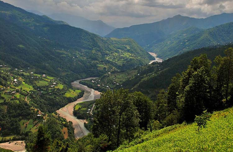
The mountainous region of Ajara includes the Keda, Khulo and Shuakhevi municipalities. Each of them is full of rich and diverse natural beauty. The Meskheti, Arsiani and Shavsheti Ranges create a very interesting geographic relief of Ajara. Their average height is between 2000-2500 meters.
Keda Municipality
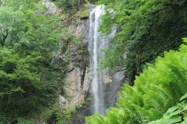
Tourists often visit Keda to see the Makhuntseti waterfall. The nearby areas offer authentic restaurants and scenic picnic locations. The Archaristkali Mountain and river gorge of Keda municipality offer vast variety of flora and fauna and beautiful landmarks, including a waterfall. The plants in the area are primarily deciduous and coniferous. The animal life in the area is also diverse. Additionally, the region has several mineral waters with unique medicinal qualities.
Shuakhevi Municipality
Shuakhevi is a typical mountainous municipality full of diverse flora and fauna. Agriculture is the main industry in Shuakhevi. The locals of Shuakhevi pride themselves on their hospitality. Visitors can get a taste of typical village life and take part in farming activities. The area is also excellent for hiking, horseback riding, rock climbing and cycling.
Khulo Municipality
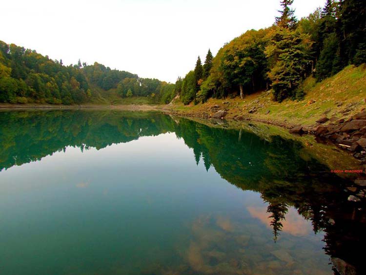
Khulo - probably the most interesting - is distinguished by its rich natural beauty, cultural sites and history. Deciduous and coniferous trees and plants predominate the area. The beautiful Mtsvane Tba (Green Lake) is located in Khulo municipality. Beshumi is a well-developed summer resort, and Goderdzi, is the ski resort located within the municipality.
In this section we will discuss in more details all the interesting villages and valleys on the way of upper Adjara Region passing all mentioned municipalities.
The order we have chosen is coming from Tbilisi towards Batumi, you can travel the same route vice versa going from Batumi up to Mountainous Ajara.
Best Time toVisit: Spring, summer, autumn
ROUTE MAP (ONE WAY)
Total Length:
Directions on Google Maps:
Even though Google Maps does not recognise this route as driveable and doesn't show directions or direct road over the Goderdzi Pass down to Batumi, we assure you that it can be travelled by 4WD vehicle without any issues. Keep in mind that you have to be prepared for difficult off road, no asphalt and muddy conditions. Double checking road condition in winter period is highly recommended.
GODERDZI PASS & SKI RESORT
Goderdzi Pass situated at the height of 2366m is a home of newly made Goderdzi Ski resort. The wilderness setting offers the visitor unique experiences, fresh-air and world-class scenery. Pristine forested mountains create a fantastic setting in the winter, summer and, most dramatically, when the autumn colors create an intense display.
More information on Goderdzi resort you can find here .
Distance from Batumi: 109 km
Distance from Tbilisi: 450 km
Altitude: 2000 m
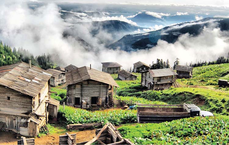
BESHUMI
Beshumi (2000 m above sea level) lies on the eastern slope of the Arsiani Range, 7 km from Goderdzi Pass.
The region is covered with sub-alpine forests and is distinguished by its clear and fresh air. The coniferous forest helps to ionize the air, making Beshumi an excellent resort for those who suffer from chronic respiratory diseases and/or bronchial asthma.
The resort is open from mid-June until early September. There are many cottages and summer houses available for rent. The traditional public festival Shuamtoba is held in mid-August and horse-racing is one of the festival's main events.
There is no public transport going to Beshumi, visitor will have to use private transport.
Distance from Batumi: 123 km
Distance from Tbilisi: 270 km
Height above sea level: 2000 meters
Best time to visit: Summer
NIGAZEULI
The gorge offers many interesting and attractive sites. On the way from Nigazeuli, we would advise you to stop at Dandalo Bridge. From here you can ascend to Otolta and Kaviani Fortresses, visit Chvana Bridge. Dandalo Bridge is right on the road, while Otolta Fortress is some 2.3 kilometers away.
Sites to visit in Nigazeuli: Nigazeuli fortress and wall (VIII AD), mosque and museum (in the village territory).
Nigazeuli Waterfall: height - approximately 20 m; the waterfall is seasonal and flows only in spring. In other seasons it’s mainly dry. The road to waterfall is quite complex so we don't recommend going there. It can be perfectly observed from the village. Below Nigazeuli, at the turn, there is Purtio Bridge and very nice restaurant with picnic and recreational area. It is possible to arrange the hiking and horse-riding tours to Chanchkhalo Fortress.
Activities: Studying animal breeding, traditional practices of poultry and vegetable farming; hiking; camping; rock climbing; skiing and sledding; hunting; fishing; observing-studying traditional knitting and tobacco processing, wine making and vodka distillation processes; preparing traditional local dishes; visiting healing-mineral springs and historic-cultural monuments.
Transportation: Mini Bus "Batumi-Nigazeuli" leaves from Batumi bus station, every day at 15:00, 18:00. Price - 5 GEL. There is no public transport from Tbilisi.
Distance from Batumi: 78 km
Altitude: 800 meters
GOBRONETI
The distance from Batumi to Gobroneti turn makes 52 kilometers. From the turn to Nigazeuli - 4.3 km. From Keda Settlement - 10 km. Tourists traveling from Batumi towards Tskhmorisi will be able to visit Acharian Wine House; historic monument Tamar’s Bridge and Makhuntseti Waterfall located in Makhuntseti community, next to the automobile road; Tsivasula Fortress, Ground Bridge and Shervashidzes' Wine Cellar in Pirveli Maisi community; Historic Museum and Zvare St. George Church in Keda Settlement.
One can visit Chonarisi Bridge, Tskhmorisi Bridge, mosque and Akho Mosque in the Gobroneti Village surroundings.
Activities: Get familiar with traditional rules of cattle breeding, poultry raising, vegetable growing, gardening and beekeeping, hiking, camping, hunting. In addition, try fishing and learn popular national trades including long-basket plaiting, knitting and iron elaboration, tobacco refining, vodka brewing, traditional ways of cooking local dishes, horse-racing, visiting historical and cultural sites.
Transportation: mini bus "Batumi-Gobroneti" - leaves from Batumi bus station on Mondays and on Fridays at 13:00, 15:00. Price - 4 GEL. There is no public transport from Tbilisi.
Distance from Batumi: 56 km
Height above sea level: 720 meters
MERISI
In the vicinity of Merisi Village it is worth visiting Namonastrevi Waterfall, Satevzia, Mindia Chkhikvadze's Wine Cellar, Namtsikhvari Fortress, tasting mineral water Gundauri.
Activities/services: walking tour around the village "Merisi", visiting local natural and cultural monuments, (Namonastrevi Waterfall, Merisi Historical Museum), tasting traditional Georgian cuisine, agro-tour - getting acquainted with typical Ajarian village life and traditional farming practices: taking care of hives and beekeeping, production of dairy, agriculture, cattle breeding, product storage, etc. Tourists can try mineral water in the nearby village "Gundauri" running naturally from the spring in the yard of one the villagers. Local population uses this water for drinking. In village "Gundauri" tourists can swim at a popular bathing place located in "Akavreta Gorge". The bathing place is not very deep. Despite this, in summer season it is still favourite cooling place for locals and guests. There are numerous picnic sites near rivers and waterfalls around Merisi Village, where travellers can temporarily forget about their problems and relax in the depth of the nature.
Transportation: mini bus "Batumi-Merisi" - leaves from Batumi bus station every day at 13:00, 15:30, 16:30, and 17:30. Price - 3 GEL.
Distance from Batumi: 45 km
Height above sea level: 736 meters
PIRVELI MAISI
One can visit Adjarian Wine House; historic monument Tamar's Bridge and Makhuntseti Waterfall located in Makhuntseti community, next to the automobile road; Tsivasula Fortress. in "Pirveli Maisi" community - ground-bridge and Shervashidzes' Wine Cellar; Historic Museum and Zvare St. George Church in Keda Settlement.
Activities/services: getting acquainted with traditional rules for gardening and horticulture, cattle breeding, aviculture, beekeeping, learning traditional recipes of local dishes, traditional handicraft knitting, embroidery, hiking, learn popular national trades - knitting, embroidery, wine making or vodka distillation (seasonal). Visit of nearby historical monuments, fishing and swimming in the river.
Transportation: Mini Bus "Batumi-Keda" leaves from Batumi bus station every day in every 15 minute. The price: 2 Gel.
Distance from Batumi: 30 km
Height above sea level: 200 meters
MACHAKHELA VALLEY
In 19 km south to Batumi there's a turn, and 3 km route will bring us from there to the Valley. So, it is just 3 km away from the main automobile road. It’s 10 km distance from the beginning of the Valley to Tskhemlara Bridge. Tourists can walk or ride horse or bicycle through the villages.
There are centuries-old arch bridges in Machakhela Valley, the biggest of them - Tskhemlara Bridge (length - 25 m, width - 2 m); here one can also visit fortresses, churches and monasteries, marani-s (wine cellars) built with the limestone and satsnakheli-s (wine squeezers), dated back to various historic periods. Several legends about Queen Tamar are associated with Machakhela Valley. In the old times, there was number of rich smitheries in the valley. Along with the family and agricultural tools, they were forging colds and firearms. At the junction of Chorokhi and Machakhela Rivers there is a monument of Machakhela gun. In Zemo Chkhutuneti Village, one casn visit is Machakhela Ethnographic Museum. In Machakhela Valley tourists might be interested in famous Machakhela honey and its manufacturing technologies.
Machakhela National Park is located at the administrative border of Khelvachauri and Keda Municipalities, in Machakhela River Valley and is the part of environmental corridor, which links together protected areas of south-west Georgia (Mtirala National Park and Kintrishi Protected Areas) and north-east Turkey (Jamil Biosphere Reserve).
Activities: Become familiar with traditional rules of cattle breeding, poultry raising, vegetable growing and beekeeping, hunting, fishing, traditional ways of cooking local dishes, hiking, camping, horse-racing, and visiting historical and cultural sites In addition, learn about the history of creating gun "Machakhela" as well as the popular national trades of knitting, embroidery, wickerwork with baskets and long baskets, wine making and vodka brewing (seasonal).
Transportation: Mini Buses "Batumi-Zeda Chkhutuneti" leaves from "Boni" bazaar every day at 16:00, 19:00. Price - 2 GEL. "Batumi-Chikuneti" - leaves from Tbilisi square at 11:00, 14:00, and 17:00. Price - 2 GEL.
Distance from Batumi: 22 km
Height above sea level: 300-800 meters
CHAKVISTAVI
Chakvistavi Village is built on the banks of Chakvistavi River and is fully surrounded by Mtirala National Park; Heading from Kobuleti to Chakvistavi by Batumi Highway, 5 km from Kobuleti and 25 km to Chakvistavi, there is a Petra Fortress. On the road from Kobuleti to center of Chakvistavi Village one will meet restaurant Champion. In Chakvistavi you will see Information Centre of Mtirala National Park, where tourists can get the entire information about the Park. On the road to Mtirala, in the centre of Chakvi Settlement, you can visit the Honey House and degustate the local honey.
Mtirala National Park is the most humid spot in the Eastern Europe. The first tourist route in Mtirala National Park starts from the Visitor Center. The path follows the left bank of Chakvistavi River, along which one can encounter the red-listed representatives of Colchic flora and fauna: marten, fox, mountain eagle, hawk, brown bear, thrush, pigeon, Georgian walnut, Colchian hazelnut. Approximately 2 km away from the Visitor's Centre, the picnic place is arranged – plateau surrounded by the sycamores; walking just 400 meters to the south-west from this spot will bring visitors to the 12 meter high waterfall decorated by the boxwood and ivy. Some 1000 meters away from this waterfall, one can see the clear river flowing among the rocks, which soon transforms into the mountain lake full of trout. There are many picnic and tenting places around the lake. The path connecting the Lake with the Visitors' Center will bring the visitors to ruins of the old abandoned settlement. It is possible to arrange water, ethnological, ecological and birdwatching tours to Mtirala Mountain.
Activities: Learn the traditional activities of gardening and vegetable growing, hiking, camping, cooking local dishes, cycling, horse-riding, visiting historical and cultural sites, hunting, fishing, wine making and vodka brewing (seasonal).
Transportation: mini Bus "Batumi-Chakvistavi" leaves from Batumi bus station on Mondays and on Friday at 16:00. Price - 3 GEL.
It is also possible to take a mini bus "Batumi-Kobuleti"/"Batumi-Chakvi" to the center of Chakvi then you can take a taxi (average price 30-40 GEL).
Mini bus "Batumi-Kobuleti"/"Batumi-Chakvi" leaves from Catholics Church (from Baku and Shavsheti str. Cross) every day, in every 30 minute. Price - 1 GEL.
More information about Mtirala National Park you can find on our National Parks page .
Distance from Batumi: 25 km
Height above sea level: 350 meters
More information about Mtirala National Park you can find on our National Parks page .
Most of texts and information on this page are taken from Official Tourism Portal of Adjara region:
RELATED ARTICLES